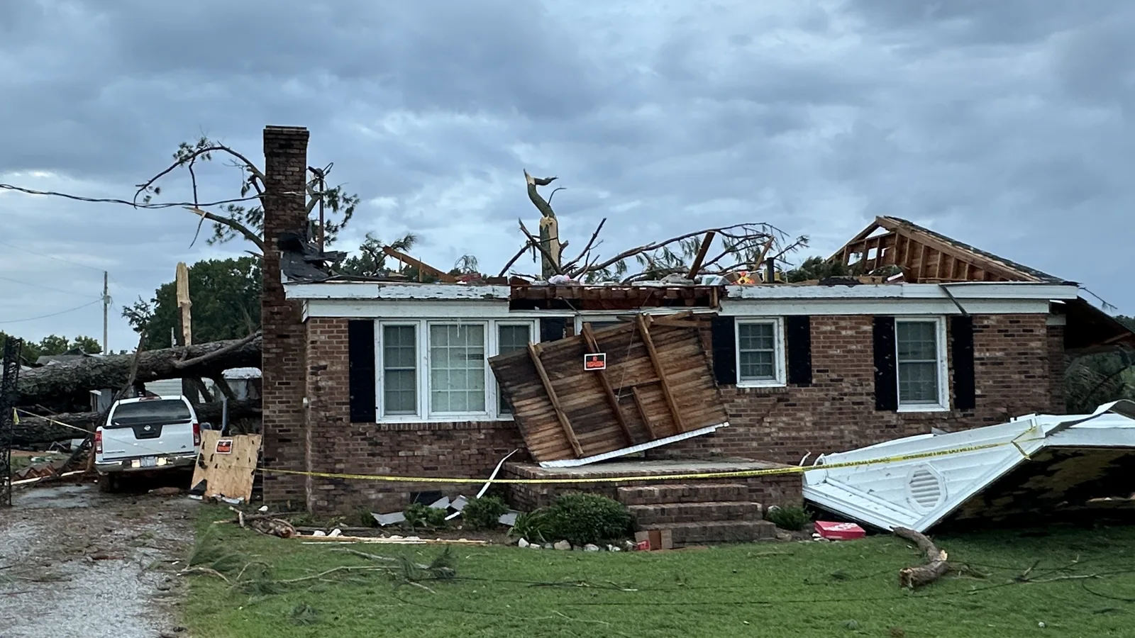
Two EF1 tornadoes hit Wake County Oct. 11, NWS surveys confirm: a 2.5-mile path from Stone Ridge to Neuse Crossing in northeast Raleigh and one in Carpenter.
Two tornadoes touched down in Wake County when the remnants of Isaias crossed central North Carolina on Sunday, Oct. 11, the National Weather Service in Raleigh has confirmed. Both were rated EF1. The stronger cut a 2.5-mile path through northeast Raleigh, from the Stone Ridge neighborhood just south of Interstate 540 north into Neuse Crossing.
Updated Oct. 16: the weather service’s damage surveys, published Oct. 12 and 13, confirm two Wake County tornadoes. This story first reported that no tornado had been confirmed.
The two Wake County tornadoes
| Northeast Raleigh | Carpenter | |
|---|---|---|
| Rating | EF1 | EF1 |
| Peak wind | 107 mph | 100 mph |
| Path | 2.51 miles | 0.37 miles |
| Widest point | 150 yards | 50 yards |
| Time on the ground | 1:12 to 1:17 p.m. | 12:29 to 12:30 p.m. |
| Injuries | None | None |
Northeast Raleigh. The tornado touched down in Stone Ridge and traveled north into Neuse Crossing, the weather service’s survey of the Perry Creek tornado said. Surveyors found a broken path of tree and structural damage. The tornado lifted near Mitchell Mill Road. Wake County Emergency Management helped with the survey.
Carpenter, western Wake County. A short-lived tornado formed near the West Regional Library on Morrisville Parkway and moved northeast, the Carpenter survey said. It snapped a large tree in the library parking lot and limbs in the neighborhood to the north. Surveyors found no structural damage. They said the strongest winds probably stayed above the ground, in the treetops.
Both ratings are preliminary until the weather service publishes its final Storm Data.
Across central North Carolina
The Raleigh office had published nine tornado surveys from Sunday by Oct. 16. Nobody was killed. One person was hurt, in the strongest track.
- EF2: Bonnie Doone, Cumberland County, 115 mph, 5.99 miles, one injury
- EF2: Candor, Montgomery County, 115 mph
- EF1: Louisburg, Franklin County, 110 mph, 1.93 miles
- EF1: northeast Raleigh, 107 mph
- EF1: Jordan Lake, Chatham County, 107 mph
- EF1: Linden, Cumberland County, 105 mph
- EF1: Carpenter, Wake County, 100 mph
- EF0: Clayton, Johnston County, 85 mph, 3.33 miles
- EF0: Harrells, Sampson County, 75 mph
The surveys are on the office’s public information statement list. Clayton is about 14 miles southeast of downtown Raleigh and Louisburg about 29 miles northeast.
No survey had been published by Oct. 16 for the damage 911 callers reported near I-440 exit 8 or north of Wendell. Without one, that damage is not a confirmed tornado.
What people reported on Sunday
The rest of this story is as first published Oct. 12.
The warnings
The weather service in Raleigh issued 16 tornado warnings across central North Carolina on Sunday, from 8:57 a.m. to 2:27 p.m. Five covered part of Wake County. Each was based on rotation seen on radar.
| Issued | Area of Wake County | Ran until |
|---|---|---|
| 11:52 a.m. | Southwest | 12:15 p.m. |
| 12:12 p.m. | Northwest | 1 p.m. |
| 1:09 p.m. | Northeast | 2 p.m. |
| 1:13 p.m. | Southeast | 2 p.m. |
| 1:40 p.m. | Northeast | 2:15 p.m. |
The 1:09 p.m. warning placed the storm near Raleigh, moving northeast at 20 mph. It said the storm would be near Raleigh and Wake Forest around 1:15 p.m. It covered I-440 between mile markers 6 and 16 and I-540 between mile markers 12 and 24. The warnings are on the weather service’s list of Raleigh office tornado warnings.
The weather service’s forecast discussion early Monday names the system as the remnants of Isaias.
What 911 callers and the public reported
The weather service logged 17 storm reports in Wake County between 12:30 and 2 p.m. Most came from the county’s 911 call center. They are in the office’s local storm reports and the Storm Prediction Center’s daily report list.
Locations are as the weather service logged them, measured from its reference points.
| Time | Where | What was reported |
|---|---|---|
| 12:31 p.m. | 3 miles N of Duncan | Tree on a house on Cass Holt Road |
| 12:32 p.m. | 1 mile E of Carpenter | Tornado, reported by the public |
| 12:51 p.m. | 2 miles SW of Raleigh | Tree down on Ridge Road |
| 12:55 p.m. | 4 miles SSW of Raleigh | Tree on power lines |
| 12:58 p.m. | 3 miles SSE of Raleigh | Tree down on train tracks |
| 12:58 p.m. | 4 miles SSE of Raleigh | Tree on a gate and partly on a house |
| 1 p.m. | 1 mile NE of Raleigh | Trees down at I-440 exit 8, possible tornado damage |
| 1 p.m. | 4 miles NNE of Raleigh | Tree down |
| 1 p.m. | 4 miles SE of Raleigh | Tree on power lines on Merrywood Drive |
| 1 p.m. | 4 miles WSW of New Hope | Power lines down on Kennedy Street |
| 1:10 p.m. | 3 miles NNE of New Hope | Tree on a house on Amber Bluffs Crescent, possible tornado damage |
| 1:15 p.m. | 5 miles SE of Falls Lake | Tree damage on Speight Circle, possible tornado damage |
| 1:17 p.m. | 5 miles SE of Falls Lake | Tree on a house, possible tornado damage |
| 1:17 p.m. | 5 miles NNE of New Hope | Tree on a house, possible tornado damage |
| 1:17 p.m. | 5 miles SW of Rolesville | Trees down on Tunas Street and Singleleaf Lane, possible tornado damage |
| 1:38 p.m. | 3 miles NNE of Wendell | Tree blocking all lanes, possible tornado damage |
| 1:38 p.m. | 4 miles NNE of Wendell | Tree and debris; road closed |
Carpenter is in western Wake County, about 12 miles west of downtown Raleigh. Duncan is about 18 miles southwest and Wendell about 15 miles east. The New Hope and Falls Lake reference points put the 1:10 to 1:17 p.m. reports in northeast Raleigh.
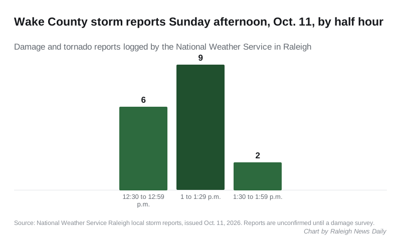
The reports came in two bursts. Six arrived between 12:30 and 12:59 p.m., nine between 1 and 1:29 p.m. and two between 1:30 and 1:59 p.m.
A 911 report is what a caller described. “Possible tornado damage” is the caller’s or the dispatcher’s wording, not a finding. Straight-line wind can snap trees too.
How much rain fell
The weather service’s rainfall summary at 8:59 p.m. Sunday listed two-day totals of 1 inch or more. In Wake County:
- 2.28 inches at a volunteer weather station in Raleigh, the county’s highest
- 2.06 inches in Cary
- 2 inches in Wake Forest
- 1.48 inches at Raleigh-Durham International Airport
Swift Creek, upstream of Queensferry Road in Cary, was at its action stage of 1.28 feet early Monday, the federal river gauge showed. Action stage is below flood stage.
What it means for you
- Downed power lines: stay away and call 911. Most of Raleigh is served by Duke Energy Progress; text OUT to 57801 or call 800-419-6356 to report an outage. Our power outages page has the outage maps and the Wake Electric numbers.
- Tree debris: see our trash and recycling guide for how yard waste is collected in Raleigh.
- Road closures: our road construction and closures page lists NCDOT’s current closures in Raleigh.
What happens next
The ratings above are preliminary. The weather service can revise a track or a rating, as it did Oct. 15 when it lengthened the Bonnie Doone path. We will update this story if it changes either Wake County survey or confirms another tornado in the county.
Have your say