Ten Raleigh areas side by side: ZIP codes, zoned high schools and August 2026 home values, from Downtown and Five Points to Brier Creek and Wakefield.
Last checked Oct. 12, 2026. Sources: the City of Raleigh’s 2030 Comprehensive Plan, area plan boundaries and Neighborhood Registry, the U.S. Census Bureau, the Wake County Public School System’s 2026-27 attendance areas, the N.C. Department of Public Instruction’s 2025-26 accountability data, OpenStreetMap and Zillow Research.
Raleigh covers about 153 square miles of land, according to the Census Bureau’s TIGERweb boundary files, and had 481,031 residents in the 2020-2024 American Community Survey, according to its QuickFacts page. Most of the city is in Wake County, with a small part in Durham County.
The city is shaped by its freeways. Interstate 440, the Beltline, circles the older center around downtown, which is why “inside the Beltline” is a common way to describe an address; the city’s own plans use the phrase. Interstate 40 runs across the south side, Interstate 540 arcs across the north, and Capital Boulevard (U.S. 1), Glenwood Avenue (U.S. 70) and New Bern Avenue run out from downtown like spokes. Fifteen ZIP codes, from 27601 to 27617, each have at least a tenth of their land inside the city, according to the Census Bureau’s 2020 ZIP code relationship file.
School zones do not follow city limits. The Wake County Public School System assigns every address in the county to a base school, so a Raleigh home can be zoned for a school in another town. Check any address with the district’s base school lookup. Durham County addresses are served by Durham Public Schools.
The areas at a glance
The ZIP code is the one most of each area falls in, and the high school is the one most points we checked were zoned for in 2026-27. Home values are the Zillow Home Value Index for that ZIP code in August 2026, a modeled typical value for the middle third of homes, not a sale price. The citywide figure was $428,671.
| Area | Main ZIP code | Zoned high school | Typical home value | Guide |
|---|---|---|---|---|
| Downtown | 27601 | Broughton | $497,314 | Downtown |
| Historic Oakwood | 27601 | Broughton | $497,314 | Historic Oakwood |
| Five Points | 27608 | Broughton | $1,046,124 | Five Points |
| Cameron Village | 27607 | Broughton | $717,268 | Cameron Village |
| North Hills | 27609 | Sanderson (most), Broughton | $552,819 | North Hills |
| Crabtree | 27612 | Broughton | $572,805 | Crabtree |
| Brier Creek | 27617 | Leesville Road | $434,865 | Brier Creek |
| Wakefield | 27614 | Wakefield | $678,013 | Wakefield |
| Avent Ferry | 27606 | Athens Drive | $437,368 | Avent Ferry |
| New Bern Avenue | 27610 | Split: Enloe, Broughton, Millbrook | $313,331 | New Bern Avenue |
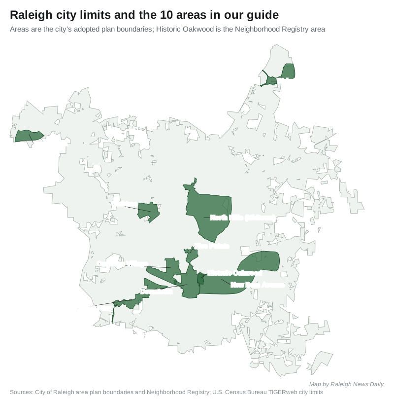
Map
Inside the Beltline
- Downtown. The State Capitol, Fayetteville Street and the Glenwood South and Warehouse districts, about 1.5 square miles in the city’s 2015 Downtown Plan. Mostly ZIP code 27601 and Broughton High.
- Historic Oakwood. The residential district on downtown’s east edge, along Oakwood Avenue, about 625 homes in the city’s registry. Conn Elementary, Oberlin Middle and Broughton High at most points we checked.
- Five Points. The area around the Glenwood Avenue, Fairview Road and Whitaker Mill Road crossing, where the city’s plan says most houses were built between 1920 and 1940. ZIP code 27608.
- Cameron Village. The shopping center now mapped as the Village District and the streets from Hillsborough Street to Wade Avenue, including Oberlin. Split between ZIP codes 27607 and 27605.
- New Bern Avenue. East Raleigh along New Bern Avenue, under the city’s 2024 station area plan, including Saint Augustine’s University and Enloe High. School assignments vary by address.
North and northwest
- North Hills. The shopping, office and apartment district at I-440 and Six Forks Road, inside the city’s Midtown plan area. ZIP code 27609.
- Crabtree. Crabtree Valley Mall and the land within about half a mile, a flood-prone valley in the city’s plan. ZIP code 27612.
- Brier Creek. Homes, apartments and shopping centers by I-540 and U.S. 70, about 4 miles by road from Raleigh-Durham International Airport. Leesville Road High.
- Wakefield. Northeast Raleigh along Falls of Neuse Road near the Neuse River, with Wakefield Elementary, Middle and High on Wakefield Pines Drive. ZIP code 27614.
South and west
- Avent Ferry. The Avent Ferry Road corridor from Western Boulevard to Tryon Road, with the Mission Valley Shopping Center and Lake Johnson Park. Athens Drive High.
To compare Raleigh with Knightdale, Garner and Cary on taxes, schools and home values, see Raleigh vs Knightdale vs Garner vs Cary. More on prices in our home prices guide, on schools in our schools guide, on taxes in our property tax guide and on moving in our moving here guide.
The city as a whole
From the Census Bureau’s 2020-2024 American Community Survey, on Raleigh’s QuickFacts page:
| Measure | Raleigh |
|---|---|
| Population | 481,031 |
| Median household income | $85,395 |
| Median value of owner-occupied homes | $415,800 |
| Mean travel time to work | 23.0 minutes |
The Census home value is what owners told the survey their homes were worth, a different measure from Zillow’s. More in our population guide.
How we built this guide
We chose areas only where a public source names them and draws them on a map. Nine are the boundaries of the City of Raleigh’s adopted area plans in its area plan data: the Downtown Plan (2015), Five Points East (2003), Cameron Village and Hillsborough Street (2018), Midtown-St. Albans (2020), Crabtree (2002), Brier Creek Village (2004), Wakefield, Avent Ferry (2019) and the New Bern Avenue station area plan (2024). Historic Oakwood is the Oakwood area in the city’s Neighborhood Registry. OpenStreetMap (© OpenStreetMap contributors) names Historic Oakwood, Five Points, North Hills, Crabtree Valley, Brier Creek, Oberlin, Glenwood South and the Warehouse District as places.
ZIP codes and school zones were checked at up to 16 points spread across each area against Census ZIP code areas and the district’s 2026-27 attendance areas. A home near a line can differ, so use the district’s lookup for a specific address. Parks come from the city’s park locator data, stores from OpenStreetMap, distances from the OSRM routing engine and bus routes from GoRaleigh and GoTriangle schedule data.
We left out names we could not place on a map from a public source this time, and broad OpenStreetMap labels such as North Raleigh, Southeast Raleigh and West Raleigh, which have no city boundary. Other adopted plan areas, including Arena-Blue Ridge, Capital Boulevard, Falls North and Dix Edge, are not covered in this guide. We found no city or county registry of mandatory homeowners associations; the city’s Neighborhood Registry lists neighborhood groups and HOAs that sign up with it, and each area page names the ones inside it.
Frequently asked questions
What are the main neighborhoods in Raleigh?
This guide covers 10 areas the city’s plans or OpenStreetMap name: Downtown, Historic Oakwood, Five Points, Cameron Village, North Hills, Crabtree, Brier Creek, Wakefield, Avent Ferry and New Bern Avenue.
Do Raleigh school zones follow city limits?
No. The Wake County Public School System assigns schools by address across the whole county, and many Raleigh homes are zoned for schools in other towns. Check an address with the district’s base school lookup.
Which Raleigh ZIP code has the highest home values?
Among Raleigh ZIP codes, 27608, which includes Five Points, had the highest Zillow Home Value Index in August 2026, $1,046,124. The citywide figure was $428,671.
How big is Raleigh?
Raleigh covers about 153 square miles of land, according to the Census Bureau, and had about 481,000 residents in the 2020-2024 American Community Survey.
Have your say